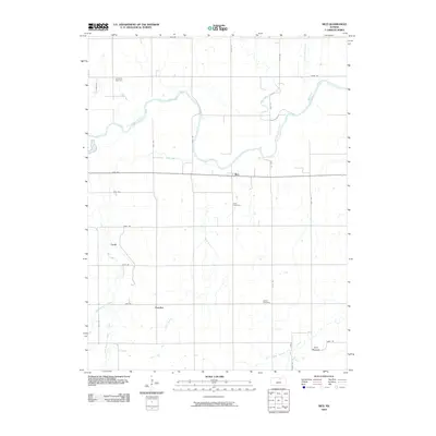
2009 Map of Rice
USGS Topo · Published 2009About this map
The Republican River meanders across the northern half of this rural Kansas landscape, defining a wide valley of riparian bends and seasonal creek confluences. In the early 21st century, the small agricultural settlement of Rice sits at the center of the sheet, served by the Rice Cemetery nearby. Further south, the communities of Cook and Huscher anchor a grid of rural roads, where the drainage systems of Oak Creek and Plum Creek begin to converge. For genealogists, the map identifies three distinct burial grounds—Gottland Cemetery, Nelson Cemetery, and the cemetery at Rice—offering precise locations for family history research. In the southeastern corner, the Twin Mounds provide a rare topographical landmark in a region otherwise characterized by a systematic network of farm-to-market roads and prairie waterways like Salt Creek.
Find a feature on this map
35 named features on this map. Tap any name to fly to it.
Don’t see what you’re looking for? This feature index may not catch every label — zoom into the map to look around manually.
Map Details
Editions of this 2009 Rice Map
This is the sole edition of this map. No revisions or reprints were ever made.
Other maps of this area

1891 · Clay Center
USGS Topo · 1:125,000

1892 · Concordia
USGS Topo · 1:125,000

1892 · Minneapolis
USGS Topo · 1:125,000

1893 · Washington
USGS Topo · 1:125,000

1955 · Manhattan
USGS Topo · 1:250,000

1956 · Manhattan
USGS Topo · 1:250,000

1957 · Manhattan
USGS Topo · 1:250,000

1965 · Aurora
USGS Topo · 1:24,000
1965 · Miltonvale NW
USGS Topo · 1:24,000
1965 · Aurora NW
USGS Topo · 1:24,000