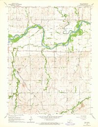
1965 Map of Rice
USGS Topo · Published 1966About this map
The Republican River winds through the northern half of this Cloud County landscape, defining the character of the Lawrence and Sibley townships. By the mid-1960s, the area's transportation history was clearly layered on the terrain, showing the active Missouri Pacific and Atchison Topeka and Santa Fe lines alongside an Old Railroad Grade and the Chicago Burlington and Quincy Railroad Grade. These rail corridors were vital to the small farming hubs of Rice and Huscher, connecting local industry like the Kilns, Claypit, and various quarries to wider markets. The rural social fabric is anchored by landmarks such as the Nelson Cemetery, Rice Cemetery, and Gottland Cemetery, while the Community Center in Nelson township served as a gathering point for the surrounding homesteads.
Find a feature on this map
32 named features on this map. Tap any name to fly to it.
Don’t see what you’re looking for? This feature index may not catch every label — zoom into the map to look around manually.
Map Details
Editions of this 1965 Rice Map
This is the sole edition of this map. No revisions or reprints were ever made.
Other maps of this area

1891 · Clay Center
USGS Topo · 1:125,000

1892 · Concordia
USGS Topo · 1:125,000

1892 · Minneapolis
USGS Topo · 1:125,000

1893 · Washington
USGS Topo · 1:125,000

1955 · Manhattan
USGS Topo · 1:250,000

1956 · Manhattan
USGS Topo · 1:250,000

1957 · Manhattan
USGS Topo · 1:250,000

1965 · Aurora
USGS Topo · 1:24,000
1965 · Miltonvale NW
USGS Topo · 1:24,000
1965 · Aurora NW
USGS Topo · 1:24,000