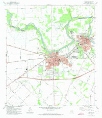
1971 Map of Richmond
USGS Topo · Published 1973About this map
The Brazos River snakes across the northern edge of this landscape, defining the physical boundary between rural agricultural lands and the growing urban centers of Richmond and Rosenberg. During the early 1970s, these two Texas towns were firmly connected by a dense network of infrastructure, including the Atchison Topeka and Santa Fe and Southern Pacific railroads. The map highlights significant local institutions such as the Richmond State Sch, Polly Ryan Memorial Hospital, and the Lamar Consolidated High Sch. Genealogists will find this particular survey especially valuable for its documentation of numerous burial grounds, ranging from the large Greenlawn Memorial Park (Cem) and Morton Cem to more secluded family or historic plots like McNabb Cem and Lightfoot Cem located near the river's bend. South of the city centers, the terrain transitions into open fields drained by Seabourne Creek and Coon Creek.
Find a feature on this map
68 named features on this map. Tap any name to fly to it.
Don’t see what you’re looking for? This feature index may not catch every label — zoom into the map to look around manually.
Map Details
Editions of this 1971 Richmond Map
2 editions found
Other maps of this area

1915 · Clodine
USGS Topo · 1:24,000

1919 · Clodine
USGS Topo · 1:31,680

1950 · Houston
USGS Topo · 1:250,000

1953 · Needville
USGS Topo · 1:24,000

1953 · Lake George
USGS Topo · 1:24,000

1953 · Kendleton
USGS Topo · 1:24,000

1955 · Sugar Land
USGS Topo · 1:62,500

1955 · Richmond
USGS Topo · 1:62,500

1956 · Houston
USGS Topo · 1:250,000
1970 · Clodine
USGS Topo · 1:24,000