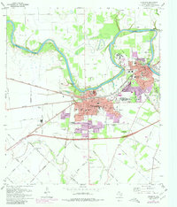
1971 Map of Richmond
USGS Topo · Published 1980About this map
The Brazos River carves a winding path through the heart of Fort Bend County, defining the spatial relationship between the neighboring towns of Richmond and Rosenberg. This era shows significant urban expansion, particularly visible in the suburban developments around Sunset Park and the extensive industrial and residential growth south of the Southern Pacific tracks. The map is a critical resource for genealogists, documenting numerous small burial grounds such as Lightfoot Cem, McNabb Cem, and Jones Cem, alongside larger institutions like the Richmond State Sch.
Find a feature on this map
85 named features on this map. Tap any name to fly to it.
Don’t see what you’re looking for? This feature index may not catch every label — zoom into the map to look around manually.
Map Details
Editions of this 1971 Richmond Map
2 editions found
Other maps of this area

1915 · Clodine
USGS Topo · 1:24,000

1919 · Clodine
USGS Topo · 1:31,680

1950 · Houston
USGS Topo · 1:250,000

1953 · Needville
USGS Topo · 1:24,000

1953 · Lake George
USGS Topo · 1:24,000

1953 · Kendleton
USGS Topo · 1:24,000

1955 · Sugar Land
USGS Topo · 1:62,500

1955 · Richmond
USGS Topo · 1:62,500

1956 · Houston
USGS Topo · 1:250,000
1970 · Clodine
USGS Topo · 1:24,000