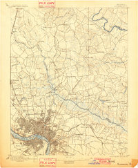
1895 Map of Richmond
USGS Topo · Published 1901About this map
The James River and its industrial corridor dominate the southern extent of this late 19th-century landscape, where a dam and Belle Id. anchor the river's path through the urban centers of Richmond and Manchester. To the north and east, the terrain transitions into the strategic crossroads and wetlands of Hanover and Henrico Counties, marked by Horse Swamp and the winding Chickahominy River. The map meticulously documents the dense network of early transportation routes, including the Richmond Fredericksburg and Potomac R.R. and the historic Mechanicsville Turnpike.
Find a feature on this map
98 named features on this map. Tap any name to fly to it.
Don’t see what you’re looking for? This feature index may not catch every label — zoom into the map to look around manually.
Map Details
Editions of this 1895 Richmond Map
5 editions found
Other maps of this area

1890 · Goochland
USGS Topo · 1:125,000

1892 · Goochland
USGS Topo · 1:125,000

1894 · Bermuda Hundred
USGS Topo · 1:62,500

1894 · Richmond
USGS Topo · 1:62,500

1895 · Richmond
USGS Topo · 1:62,500

1897 · Amelia
USGS Topo · 1:125,000

1918 · Charles City
USGS Topo · 1:62,500

1918 · Doswell
USGS Topo · 1:62,500

1918 · Aylett
USGS Topo · 1:62,500

1920 · King William
USGS Topo · 1:62,500