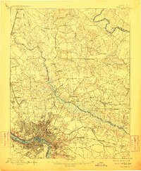
1895 Map of Richmond
USGS Topo · Published 1911About this map
The post-Civil War landscape of central Virginia is defined by a dense network of river crossings and small crossroads communities. Situated at the falls of the James River, the city of Manchester and the Rocketts district anchor the southern portion of the sheet, while the Chickahominy River creates a broad, swampy corridor through the center. This survey, conducted between 1889 and 1892, preserves the exact locations of sites central to regional history, including Cold Harbor and Seven Pines. To the north, the Richmond Fredericksburg and Potomac R.R. connects northern outposts like Ashland and Gwathmey to the urban core. Local commerce is visible in the numerous mills and ferries, such as Branche Mill on Beaverdam Creek and Nelson Ferry on the Pamunkey River, while several National Cemetery locations and country churches like Merry Oaks Church provide vital landmarks for genealogical research.
Find a feature on this map
94 named features on this map. Tap any name to fly to it.
Don’t see what you’re looking for? This feature index may not catch every label — zoom into the map to look around manually.
Map Details
Editions of this 1895 Richmond Map
5 editions found
Other maps of this area

1890 · Goochland
USGS Topo · 1:125,000

1892 · Goochland
USGS Topo · 1:125,000

1894 · Bermuda Hundred
USGS Topo · 1:62,500

1894 · Richmond
USGS Topo · 1:62,500

1895 · Richmond
USGS Topo · 1:62,500

1897 · Amelia
USGS Topo · 1:125,000

1918 · Charles City
USGS Topo · 1:62,500

1918 · Doswell
USGS Topo · 1:62,500

1918 · Aylett
USGS Topo · 1:62,500

1920 · King William
USGS Topo · 1:62,500