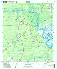
1997 Map of Richmond Hill
USGS Topo · Published 1999About this map
The Ogeechee River and Canoochee River define this coastal Georgia landscape, where tidal marshes and complex water systems intersect with local settlements. Significant engineering is evident in the dense network of drainage channels such as the Peachtree Canal, Valambrosia Canal, and Red Dock Canal, which reflect the historic agricultural and timber-based economy of the region. Near the center, Richmond Hill serves as a primary hub, surrounded by smaller locales like Brisbon, Port Royal, and Daniel. The area is notably dense with genealogical sites, including several family and community burial grounds such as Bethlehem Cem, Strathy Hall Cem, and Patterson Cem. A portion of the Fort Stewart Military Reservation occupies the western sector, while the Belfast Siding and Old Railroad Grade trace the legacy of local rail transport through the Poplar Swamp.
Find a feature on this map
57 named features on this map. Tap any name to fly to it.
Don’t see what you’re looking for? This feature index may not catch every label — zoom into the map to look around manually.
Map Details
Editions of this 1997 Richmond Hill Map
This is the sole edition of this map. No revisions or reprints were ever made.
Other maps of this area

1920 · Meldrim
USGS Topo · 1:62,500

1920 · Limerick
USGS Topo · 1:62,500

1942 · Meldrim
USGS Topo · 1:62,500

1942 · Savannah
USGS Topo · 1:62,500

1944 · Limerick
USGS Topo · 1:62,500

1944 · Ossabaw Island
USGS Topo · 1:62,500

1945 · Ossabaw Island
USGS Topo · 1:62,500

1946 · Brunswick
USGS Topo · 1:250,000

1947 · Savannah
USGS Topo · 1:250,000

1948 · Brunswick
USGS Topo · 1:250,000