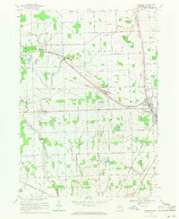
1968 Map of Richmond
USGS Topo · Published 1971About this map
The agricultural landscape of Macomb County is defined by a dense network of drainage channels and small watercourses like the Salt River and Coon Creek. In the late 1960s, the village of Armada and the city of Richmond served as local hubs, connected by the Grand Trunk Western railroad. The map reveals the social fabric of the era through institutional landmarks such as the St Joseph Novitiate and several rural churches, including St Mary Ch and Independent Ch. Small burial grounds like Bates Cem and Richards Cem are scattered across the township, offering specific points of interest for genealogists. The land use is primarily rural, punctuated by numerous Gravel Pits and a complex system of named drains like the Ray-Lenox Drain and Harrison Drain, which were essential for managing the low-lying terrain of Lenox and Richmond townships.
Find a feature on this map
65 named features on this map. Tap any name to fly to it.
Don’t see what you’re looking for? This feature index may not catch every label — zoom into the map to look around manually.
Map Details
Editions of this 1968 Richmond Map
2 editions found
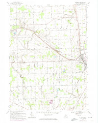
Other maps of this area

1912 · Mt Clemens
USGS Topo · 1:62,500

1914 · Armada
USGS Topo · 1:62,500

1914 · Algonac
USGS Topo · 1:62,500

1928 · Armada
USGS Topo · 1:62,500

1928 · Hicky
USGS Topo · 1:62,500

1929 · Mt Clemens
USGS Topo · 1:62,500

1936 · New Haven
USGS Topo · 1:31,680

1936 · Waldenburg
USGS Topo · 1:31,680

1936 · New Baltimore
USGS Topo · 1:31,680

1939 · New Baltimore
USGS Topo · 1:24,000