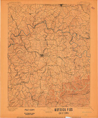
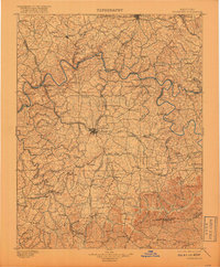
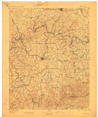
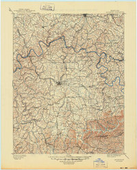
1897 Map of Richmond
USGS Topo · Published 1906About this map
Boonesboro and the winding course of the Kentucky River dominate the northern landscape of this Central Kentucky survey, reflecting a region defined by river crossings and early rail development. At the center lies Richmond, a hub where the Kentucky Central R.R. meets local roads, surrounded by numerous small farming settlements like White Hall and Athens. The map captures a transition in transportation as traditional ferries at Valley View and Ford operate alongside the expanding infrastructure of the Louisville and Nashville R.R. and the Chesapeake and Ohio R.R.. To the south, the topography shifts toward the prominent knobs of Combs Mtn. and Joe Lick Knob, marking the rugged ascent toward the hills. Industry is represented by a Stone Quarry near the eastern boundary, while the river’s deep meanders around Cleveland and Doylesville illustrate the geographical barriers that shaped the early settlement patterns of Madison and Fayette counties.
Find a feature on this map
148 named features on this map. Tap any name to fly to it.
Don’t see what you’re looking for? This feature index may not catch every label — zoom into the map to look around manually.
Map Details
Editions of this 1897 Richmond Map
5 editions found
Other maps of this area

1891 · Manchester
USGS Topo · 1:125,000

1892 · Richmond
USGS Topo · 1:125,000

1892 · Beattyville
USGS Topo · 1:125,000

1893 · London
USGS Topo · 1:125,000

1897 · Richmond
USGS Topo · 1:125,000

1897 · London
USGS Topo · 1:125,000

1905 · Harrodsburg
USGS Topo · 1:125,000

1906 · Georgetown
USGS Topo · 1:62,500

1908 · Georgetown
USGS Topo · 1:62,500

1927 · Lexington
USGS Topo · 1:48,000