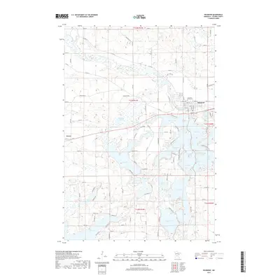
2019 Map of Richmond
USGS Topo · Published 2019About this map
The Sauk River winds through this Central Minnesota landscape, defining the northern edge of a dense glacial lake chain that characterizes the region. In the northeast, the settlement of Richmond is established along the river banks, anchored by the Saints Peter and Paul Cem. The topography is defined by an intricate network of interconnected water bodies, including the complex shorelines of Horseshoe Lake, Cedar Island Lake, and Big Lake. Further west, the small community of Roscoe sits near the intersection of Co Rd 114 and Co Hwy 12. This 2019 survey illustrates a landscape where residential development and recreational property are tightly integrated with the natural hydrology of the lakes, from the smaller Meyers Lake to the sprawling Long Lake and Browns Lake in the south. The township grid is clearly marked by a series of numbered county roads and local streets like W Torah Dr, which connect these dispersed waterfront settlements.
Find a feature on this map
81 named features on this map. Tap any name to fly to it.
Don’t see what you’re looking for? This feature index may not catch every label — zoom into the map to look around manually.
Map Details
Editions of this 2019 Richmond Map
This is the sole edition of this map. No revisions or reprints were ever made.
Other maps of this area

1953 · Saint Cloud
USGS Topo · 1:250,000

1957 · Saint Cloud
USGS Topo · 1:250,000

1958 · Saint Cloud
USGS Topo · 1:250,000

1965 · Farming
USGS Topo · 1:24,000

1965 · St Martin
USGS Topo · 1:24,000

1965 · Avon
USGS Topo · 1:24,000

1967 · Cold Spring
USGS Topo · 1:24,000

1967 · Paynesville
USGS Topo · 1:24,000

1967 · Lake Koronis
USGS Topo · 1:24,000

1967 · Richmond
USGS Topo · 1:24,000