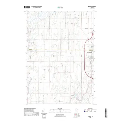
2018 Map of Richwood
USGS Topo · Published 2018About this map
The Crawfish River and Beaver Dam River converge in this agricultural landscape on the border of Dodge and Jefferson Counties. This 2018 survey highlights the small communities of Richwood and Grellton, which sit amidst a network of rural roads such as Co RD Q and Co RD G. The map detail is particularly useful for local historians, as it identifies family and community landmarks like Al's Airway and the Mamre Moravian Cem. To the east, the outskirts of Watertown begin to appear, marked by residential developments like Steeplechase Dr and Autumn Crest Dr. The drainage patterns surrounding Hahns Lake and the Rock River illustrate the low-lying, water-rich geography of this part of southern Wisconsin, where county lines follow established property and section grids.
Find a feature on this map
76 named features on this map. Tap any name to fly to it.
Don’t see what you’re looking for? This feature index may not catch every label — zoom into the map to look around manually.
Map Details
Editions of this 2018 Richwood Map
This is the sole edition of this map. No revisions or reprints were ever made.
Other maps of this area

1891 · Waterloo
USGS Topo · 1:62,500

1892 · Watertown
USGS Topo · 1:62,500

1894 · Waterloo
USGS Topo · 1:62,500

1894 · Watertown
USGS Topo · 1:62,500

1910 · Waterloo
USGS Topo · 1:62,500

1955 · Beaver Dam
USGS Topo · 1:62,500

1955 · Horicon
USGS Topo · 1:62,500

1957 · Madison
USGS Topo · 1:250,000
1959 · Richwood
USGS Topo · 1:24,000
1959 · Waterloo
USGS Topo · 1:24,000