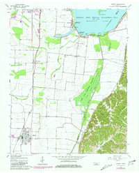
1964 Map of Ridgely
USGS Topo · Published 1981About this map
Reelfoot Lake dominates this Western Tennessee landscape, where the flat, fertile Mississippi River floodplains meet the protected wetlands of the Reelfoot State Wildlife Management Area. The map reveals a complex water management system essential for local agriculture, featuring a prominent Levee, a network of Ditch lines, and a massive Spoil Bank alongside the Running watercourse. Settlement patterns are tied to the Illinois Central Gulf railroad, which links the commercial hub of Ridgely to smaller communities like Wynnburg and Tiptonville. This 1964 survey (with 1981 revisions) is particularly valuable for genealogists, as it meticulously identifies numerous small family and community burial grounds, including Burrus Cem, New Haven Cem, and the Crocketts Chapel cemetery. Landmarks of mid-century leisure, such as the Drive-in Theater near Wynnburg and Sunkist Beach, appear alongside industrial features like the Gravel Pits in the southeast.
Find a feature on this map
53 named features on this map. Tap any name to fly to it.
Don’t see what you’re looking for? This feature index may not catch every label — zoom into the map to look around manually.
Map Details
Editions of this 1964 Ridgely Map
2 editions found
Other maps of this area

1925 · Reelfoot Lake
USGS Topo · 1:62,500

1939 · Reelfoot Lake
USGS Topo · 1:62,500

1939 · Portageville
USGS Topo · 1:62,500

1939 · Dyersburg
USGS Topo · 1:62,500

1939 · Caruthersville
USGS Topo · 1:62,500

1951 · Caruthersville
USGS Topo · 1:62,500

1952 · Lane
USGS Topo · 1:24,000

1952 · Miston
USGS Topo · 1:24,000

1955 · Portageville
USGS Topo · 1:62,500

1956 · Reelfoot Lake
USGS Topo · 1:62,500