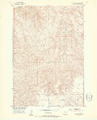
1951 Map of Ridgeview NE
USGS Topo · Published 1953About this map
The Cheyenne River Indian Reservation landscape is defined by the winding course of the Moreau R in the northwest and a network of seasonal drainages including Swan Creek and Bull Creek. This early 1950s survey shows a sparsely settled ranching region in Dewey County characterized by expansive, high-plateau terrain and deep-cut draws. Notable human landmarks are few, reflecting the remote character of the period. The Bauer Sch stands as a central point of local geography in the southern section, while a Spillway 2228 near the southeastern corner indicates early water management efforts in the Missouri River Basin. This map provides a detailed look at the rural infrastructure and land divisions within the reservation before further modern development altered the local landscape.
Find a feature on this map
8 named features on this map. Tap any name to fly to it.
Don’t see what you’re looking for? This feature index may not catch every label — zoom into the map to look around manually.
Map Details
Editions of this 1951 Ridgeview NE Map
3 editions found
Other maps of this area

1951 · Ridgeview NW
USGS Topo · 1:24,000

1951 · Ridgeview NE
USGS Topo · 1:24,000

1951 · La Plant
USGS Topo · 1:24,000

1952 · Whitehorse
USGS Topo · 1:24,000

1952 · Trail City SW
USGS Topo · 1:24,000

1952 · Glencross SE
USGS Topo · 1:24,000

1953 · McIntosh
USGS Topo · 1:250,000

1958 · McIntosh
USGS Topo · 1:250,000
1981 · La Plant SW
USGS Topo · 1:24,000
1981 · Ridgeview
USGS Topo · 1:24,000