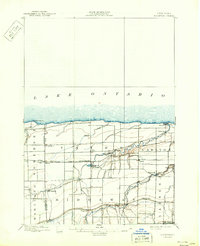
1897 Map of Ridgeway
USGS Topo · Published 1943About this map
Lake Ontario defines the northern edge of this 1896 survey, where the Thirtymile Pt. L.H. stands as a sentinel over the shoreline. The interior landscape is a structured grid of agricultural townships like Yates and Carlton, deeply etched by the meandering courses of Oak Orchard Creek and Johnson Creek. These waterways, particularly near Waterport and Johnson, dictated the early placement of mills and small hubs long before the modern highway system reorganized the region.
Find a feature on this map
36 named features on this map. Tap any name to fly to it.
Don’t see what you’re looking for? This feature index may not catch every label — zoom into the map to look around manually.
Map Details
Editions of this 1897 Ridgeway Map
5 editions found
Other maps of this area

1897 · Albion
USGS Topo · 1:62,500

1897 · Olcott
USGS Topo · 1:62,500

1897 · Medina
USGS Topo · 1:62,500

1897 · Lockport
USGS Topo · 1:62,500

1897 · Oak Orchard
USGS Topo · 1:62,500

1897 · Ridgeway
USGS Topo · 1:62,500

1899 · Niagara
USGS Topo · 1:125,000

1902 · Lockport
USGS Topo · 1:62,500

1905 · Lockport
USGS Topo · 1:62,500

1944 · Ashwood
USGS Topo · 1:31,680