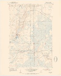
1952 Map of Riley
USGS Topo · Published 1954About this map
Industrial transport and forestry define this northern Minnesota landscape in the early 1950s. The Great Northern and Duluth Missabe and Iron Range railroads cross the northern sections, facilitating the region's resource extraction economy alongside local infrastructure like the Pumping Station and several Gravel Pit operations. The small settlement of Riley sits at a critical junction of these rail lines and roadways, serving as a focal point for the surrounding rural area.
Find a feature on this map
16 named features on this map. Tap any name to fly to it.
Don’t see what you’re looking for? This feature index may not catch every label — zoom into the map to look around manually.
Map Details
Editions of this 1952 Riley Map
3 editions found
Other maps of this area

1951 · Hibbing
USGS Topo · 1:24,000

1951 · Buhl
USGS Topo · 1:24,000

1952 · Keewatin
USGS Topo · 1:24,000

1952 · Riley
USGS Topo · 1:24,000

1952 · Silica
USGS Topo · 1:24,000

1952 · Little Swan
USGS Topo · 1:24,000

1954 · Hibbing
USGS Topo · 1:250,000

1957 · Hibbing
USGS Topo · 1:250,000

1957 · Hibbing
USGS Topo · 1:24,000

1958 · Hibbing
USGS Topo · 1:250,000