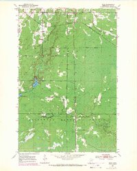
1952 Map of Riley
USGS Topo · Published 1971About this map
Riley and its surrounding wetlands occupy a landscape defined by the iron country's industrial infrastructure and forest management in northern Minnesota. The Burlington Northern line cuts across the northern terrain, passing through the small settlement where a Town Hall and Maple Hill Sch served the local community. Significant portions of the quadrangle are dedicated to conservation, notably within the Floodwood Memorial Forest and across the Stuntz Forest Boundary. Hydrological features like the Swan River and the connected waters of Harriett Lake and Little Harriett Lake dominate the central and southern sections, punctuated by a former Railroad Grade. This mapping reflects a mid-century period of land use where resource extraction, indicated by various Gravel Pits, coexisted with expansive state forest preserves and isolated rural outposts.
Find a feature on this map
17 named features on this map. Tap any name to fly to it.
Don’t see what you’re looking for? This feature index may not catch every label — zoom into the map to look around manually.
Map Details
Editions of this 1952 Riley Map
3 editions found
Other maps of this area

1951 · Hibbing
USGS Topo · 1:24,000

1951 · Buhl
USGS Topo · 1:24,000

1952 · Keewatin
USGS Topo · 1:24,000

1952 · Riley
USGS Topo · 1:24,000

1952 · Silica
USGS Topo · 1:24,000

1952 · Little Swan
USGS Topo · 1:24,000

1954 · Hibbing
USGS Topo · 1:250,000

1957 · Hibbing
USGS Topo · 1:250,000

1957 · Hibbing
USGS Topo · 1:24,000

1958 · Hibbing
USGS Topo · 1:250,000