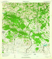
1960 Map of Rio Descalabrado
USGS Topo · Published 1962About this map
Lago Guayabal and the surrounding agricultural valleys dominate this landscape in south-central Puerto Rico, where the coastal plains meet the southern foothills of the Cordillera Central. The map captures a transition from the rugged topography of Hato Puerco Arriba and Caonillas Arriba to the intensive sugar and cattle lands of the south. Grounded in the agrarian history of the region, several named estates are visible, including Hacienda Miranda, Hacienda Amelia, and Hacienda Ursula, reflecting the long-standing plantation economy near the Fort Allen Military Reservation.
Find a feature on this map
66 named features on this map. Tap any name to fly to it.
Don’t see what you’re looking for? This feature index may not catch every label — zoom into the map to look around manually.
Map Details
Editions of this 1960 Rio Descalabrado Map
2 editions found
Other maps of this area

1944 · Santa Isabel
USGS Topo · 1:30,000

1945 · Playa De Ponce
USGS Topo · 1:30,000

1945 · Ponce
USGS Topo · 1:30,000

1945 · Rio Descalabrado
USGS Topo · 1:30,000

1945 · Salinas
USGS Topo · 1:30,000

1946 · Coamo
USGS Topo · 1:30,000

1946 · Barranquitas
USGS Topo · 1:30,000

1946 · Jayuya
USGS Topo · 1:30,000

1946 · Orocovis
USGS Topo · 1:30,000

1947 · Ponce NE
USGS Topo · 1:10,000
Featured Places
- Comunidad Johnny Tosco, Coamo
- Quintas del Llano, Coamo
- Villa Geraldina, Juana Díaz
- Sector Sierrita, Coamo
- Sector Verdún, Coamo