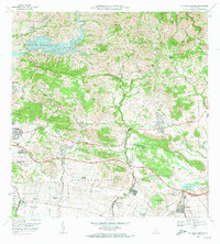
1972 Map of Rio Descalabrado
USGS Topo · Published 1974About this map
Agricultural lands and industrial waterworks define this 1970s landscape where the Represa De Toa Vaca and Lago Guayabal manage the flow of the Rio Toa Vaca. The southern coastal plain is marked by several traditional estates, including Hacienda Miranda, Hacienda Amelia, and Hacienda Ursula, reflecting the region’s agrarian history near Paso Seco. Infrastructure for communication and transport is prominent, evidenced by the Fort Allen Naval Radio Station and a series of complex irrigation canals and a Pista De Aterrizaje. Elevations rise sharply toward the north with peaks like Cerro Petronila and Cerro La Coroza, while the transition to the lowlands is dotted with local schools such as Escuela Santaella and Escuela Tijeras. The map captures a moment of modernization in the municipality of Juana Diaz before further suburban expansion changed the character of these historic barrios.
Find a feature on this map
66 named features on this map. Tap any name to fly to it.
Don’t see what you’re looking for? This feature index may not catch every label — zoom into the map to look around manually.
Map Details
Editions of this 1972 Rio Descalabrado Map
4 editions found

Other maps of this area

1944 · Santa Isabel
USGS Topo · 1:30,000

1945 · Playa De Ponce
USGS Topo · 1:30,000

1945 · Ponce
USGS Topo · 1:30,000

1945 · Rio Descalabrado
USGS Topo · 1:30,000

1945 · Salinas
USGS Topo · 1:30,000

1946 · Coamo
USGS Topo · 1:30,000

1946 · Barranquitas
USGS Topo · 1:30,000

1946 · Jayuya
USGS Topo · 1:30,000

1946 · Orocovis
USGS Topo · 1:30,000

1947 · Ponce NE
USGS Topo · 1:10,000
Featured Places
- Comunidad Johnny Tosco, Coamo
- Quintas del Llano, Coamo
- Villa Geraldina, Juana Díaz
- Sector Sierrita, Coamo
- Sector Verdún, Coamo