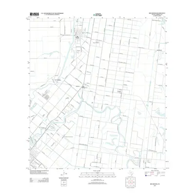
2013 Map of Rio Hondo
USGS Topo · Published 2013About this map
Arroyo Colorado snakes through this coastal prairie landscape, anchoring the settlement of Rio Hondo and the industrial activity at Port Harlingen. The 2013 landscape is defined by a dense grid of farm-to-market roads and irrigation infrastructure, including the Lateral R Canal and several significant water bodies like Montgomery Reservoir and Sweeney Lake. This survey illustrates the intricate balance between agricultural irrigation and local aviation, with both the Texas Air Museum Airport and Kornegay Private Airport situated among the fields. Small communities such as Lozano, Lantana, and Las Yescas are interspersed throughout the quadrangle, while the Monte Meta Cem serves as a prominent local landmark. The layout of the road network, including Farm-to-Market Road 398 and General Grant Rd, reveals a highly organized land-use pattern typical of this region's modern development.
Find a feature on this map
140 named features on this map. Tap any name to fly to it.
Don’t see what you’re looking for? This feature index may not catch every label — zoom into the map to look around manually.
Map Details
Editions of this 2013 Rio Hondo Map
This is the sole edition of this map. No revisions or reprints were ever made.
Other maps of this area

1929 · Rio Hondo
USGS Topo · 1:24,000

1929 · Harlingen
USGS Topo · 1:24,000

1929 · La Paloma
USGS Topo · 1:24,000

1930 · Los Fresnos
USGS Topo · 1:24,000

1930 · Barreda
USGS Topo · 1:24,000

1930 · La Leona
USGS Topo · 1:24,000

1930 · Laguna Atascosa
USGS Topo · 1:24,000

1932 · Combes
USGS Topo · 1:31,680

1932 · Rio Hondo
USGS Topo · 1:31,680

1932 · Harlingen
USGS Topo · 1:31,680