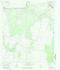
1963 Map of Rio Pecos Ranch
USGS Topo · Published 1981About this map
The Waha Oil Field dominates this West Texas landscape, illustrating the intensive industrial footprint of petroleum extraction across the Chihuahuan Desert during the mid-20th century. A dense network of wells, pipelines, and dirt tracks reveals the organized development of the basin, contrasting sharply with the intermittent watercourses of Hackberry Draw and Coyanosa Draw. Along the northern edge of the sheet, the Pecos River serves as the primary artery for agricultural survival, flanked by the Imperial Ditch and the Grandfalls Canal. These irrigation features highlight the dual economy of the region, where water management for ranching and farming exists alongside mineral extraction. Further south, a remote Landing Strip and isolated landmarks like Twin Windmills provide evidence of the vast distances and specialized infrastructure required to manage these outlying ranch lands and industrial sites.
Find a feature on this map
12 named features on this map. Tap any name to fly to it.
Don’t see what you’re looking for? This feature index may not catch every label — zoom into the map to look around manually.
Map Details
Editions of this 1963 Rio Pecos Ranch Map
3 editions found
Other maps of this area

1931 · Barstow
USGS Topo · 1:125,000

1954 · Pecos
USGS Topo · 1:250,000

1957 · Pecos
USGS Topo · 1:250,000

1963 · Ligon Ranch
USGS Topo · 1:24,000

1963 · China Lake NE
USGS Topo · 1:24,000

1963 · Rio Pecos Ranch
USGS Topo · 1:24,000

1963 · China Lake
USGS Topo · 1:24,000

1969 · 7 L Ranch
USGS Topo · 1:24,000
1973 · Coyanosa NW
USGS Topo · 1:24,000
1974 · Coyanosa
USGS Topo · 1:24,000