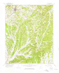
1955 Map of Ripley
USGS Topo · Published 1976About this map
Ripley serves as the focal point of this mid-century landscape, where the Gulf Mobile and Ohio railroad cuts a north-south line through the heart of Tippah County. The terrain is defined by complex drainage basins, including the headwaters of the Hatchie River and the Little Hatchie River, which give way to broad bottomlands like Green Bottom and Gus Bottom. These fertile lowlands are contrasted by notable elevations such as Oil Mill Hill and the Scruggs Hills.
Find a feature on this map
153 named features on this map. Tap any name to fly to it.
Don’t see what you’re looking for? This feature index may not catch every label — zoom into the map to look around manually.
Map Details
Editions of this 1955 Ripley Map
2 editions found
Other maps of this area

1921 · Booneville
USGS Topo · 1:48,000

1921 · Tupelo
USGS Topo · 1:48,000

1922 · Booneville
USGS Topo · 1:62,500

1923 · Tupelo
USGS Topo · 1:62,500

1949 · New Albany
USGS Topo · 1:62,500

1950 · Ashland
USGS Topo · 1:62,500

1950 · Corinth
USGS Topo · 1:62,500

1951 · New Albany
USGS Topo · 1:62,500

1951 · Walnut
USGS Topo · 1:62,500

1955 · Ripley
USGS Topo · 1:62,500