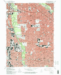
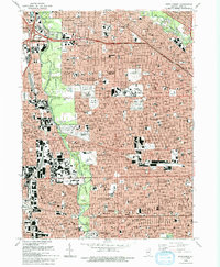
1993 Map of River Forest
USGS Topo · Published 1993About this map
The Des Plaines River corridor serves as a central artery through this dense suburban landscape, flanked by extensive forest preserves such as Schiller Woods North and Robinson Woods North. This map documents a high concentration of institutional and communal landmarks, including the campus of Concordia University and the specialized grounds of the Chicago-Read Mental Health Center. The western edge of Chicago and adjacent communities like River Forest and Elmwood Park are characterized by a precise grid of residential streets, punctuated by dozens of parochial schools and large commemorative spaces like St Joseph Cemetery and Elmwood Cemetery. Transportation networks define the area's movement, with the Kennedy Expressway and Soo Line tracks cutting through the built environment. Unique recreation and health sites, from the Maywood Park Racetrack and Kiddieland Park to Shriners Hospital, reflect the mid-century development of these Cook County suburbs.
Find a feature on this map
152 named features on this map. Tap any name to fly to it.
Don’t see what you’re looking for? This feature index may not catch every label — zoom into the map to look around manually.
Map Details
Editions of this 1993 River Forest Map
2 editions found
Other maps of this area

1889 · Chicago
USGS Topo · 1:62,500

1891 · Chicago
USGS Topo · 1:62,500

1891 · Riverside
USGS Topo · 1:62,500

1893 · Riverside
USGS Topo · 1:62,500

1899 · Evanston
USGS Topo · 1:62,500

1900 · Chicago
USGS Topo · 1:62,500

1900 · Riverside
USGS Topo · 1:62,500

1900 · Highwood
USGS Topo · 1:62,500

1901 · Riverside
USGS Topo · 1:62,500

1901 · Chicago
USGS Topo · 1:62,500