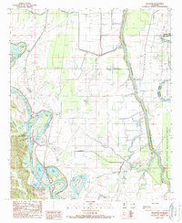
1989 Map of Riverton
USGS Topo · Published 1989About this map
The Ouachita River defines the western reach of this Caldwell Parish landscape, where the Columbia Lock and Dam controls the river's flow near the settlement of Riverton. This 1989 provisional map illustrates an intricate riparian network including the Boeuf River and Bayou Lafourche as they wind through the eastern lowlands. The central plain is marked by agricultural roads and small clusters at Cane Hill and Corey, while the eastern portion is dominated by the Boeuf State Wildlife Management Area. Numerous oxbow lakes and bayous, such as Davis Lake, McEnery Lake, and Horseshoe Lake, suggest a dynamic floodplain managed by a system of levees. Significant infrastructure like the Caldwell Parish Airport and multiple pumping stations highlight the mid-century engineering required to support rural life and commerce in the Louisiana delta.
Find a feature on this map
35 named features on this map. Tap any name to fly to it.
Don’t see what you’re looking for? This feature index may not catch every label — zoom into the map to look around manually.
Map Details
Editions of this 1989 Riverton Map
This is the sole edition of this map. No revisions or reprints were ever made.
Other maps of this area

1935 · Alto
USGS Topo · 1:62,500

1939 · Fort Necessity
USGS Topo · 1:62,500

1940 · Monroe
USGS Topo · 1:62,500

1940 · Columbia
USGS Topo · 1:62,500

1955 · Jackson
USGS Topo · 1:250,000

1955 · Shreveport
USGS Topo · 1:250,000

1956 · Shreveport
USGS Topo · 1:250,000

1957 · Columbia
USGS Topo · 1:62,500

1957 · Mangham
USGS Topo · 1:62,500

1957 · Monroe South
USGS Topo · 1:62,500