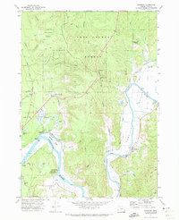
1971 Map of Riverton
USGS Topo · Published 1973About this map
Coquille River winding through the coastal lowlands of Coos County defines the industrial and agricultural character of this 1971 survey. The landscape is a complex network of waterways, featuring the prominent Beaver Slough and Randolph Slough, which separate local hills like Offield Hill and Hatchet Hill from the river's main channel. The presence of numerous Cranberry Bogs near Randolph and Prosper highlights the specialized agricultural development of the Oregon coast during this era.
Find a feature on this map
53 named features on this map. Tap any name to fly to it.
Don’t see what you’re looking for? This feature index may not catch every label — zoom into the map to look around manually.
Map Details
Editions of this 1971 Riverton Map
2 editions found
Other maps of this area

1896 · Coos Bay
USGS Topo · 1:125,000

1898 · Coos Bay
USGS Topo · 1:125,000

1900 · Coos Bay
USGS Topo · 1:125,000

1942 · Empire
USGS Topo · 1:62,500

1942 · Coquille
USGS Topo · 1:62,500

1942 · Coos Bay
USGS Topo · 1:62,500

1943 · Bandon
USGS Topo · 1:62,500

1944 · Empire
USGS Topo · 1:62,500

1944 · Bandon
USGS Topo · 1:62,500

1945 · Coquille
USGS Topo · 1:62,500