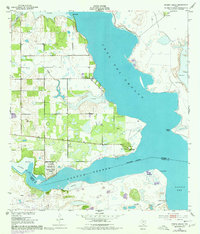
1952 Map of Riviera Beach
USGS Topo · Published 1977About this map
Coastal settlements along the brackish reaches of Baffin Bay define this 1952 study, which captures the intersection of ranching, military history, and the Gulf Coast environment. The map details the shores of Cayo Del Grullo and Laguna Salada, where the local landscape is marked by unique features like Robbins Esc and the small community at Loyola Beach. Of particular historical interest is the U S Naval Reservation Auxiliary Field 65 (Inactive) located near the Kleberg-Kenedy county line, illustrating the region's mid-century strategic role. Inland, the map reveals a pattern of resource extraction and water management through numerous oil wells and sites like Loma Prieta Artesian Well and Las Puertas Artesian Well. These landmarks, alongside coastal points like Drum Pt and Sandy Hook, provide a precise look at the area before later 20th-century developments altered the character of the shoreline.
Find a feature on this map
26 named features on this map. Tap any name to fly to it.
Don’t see what you’re looking for? This feature index may not catch every label — zoom into the map to look around manually.
Map Details
Editions of this 1952 Riviera Beach Map
4 editions found
Other maps of this area

1928 · Sarita
USGS Topo · 1:125,000

1950 · Corpus Christi
USGS Topo · 1:250,000

1951 · Kleberg Point
USGS Topo · 1:24,000

1951 · Riviera Beach NE
USGS Topo · 1:24,000

1951 · Sarita 4 NE
USGS Topo · 1:24,000

1952 · Riviera Beach
USGS Topo · 1:24,000

1952 · La Parra Ranch
USGS Topo · 1:24,000

1952 · Riviera Beach NW
USGS Topo · 1:24,000

1952 · Riviera Beach
USGS Topo · 1:62,500

1954 · Sarita
USGS Topo · 1:62,500