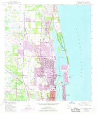
1946 Map of Riviera Beach
USGS Topo · Published 1968About this map
Riviera Beach and the burgeoning Atlantic coastline of the late 1960s appear here in a state of rapid post-war transformation. This coastal landscape is defined by the Intracoastal Waterway and the expansive Lake Worth, which separate the mainland from Singers Island and the exclusive enclaves of Palm Beach Shores. The settlement pattern reveals the planned growth of North Palm Beach and Lake Park, where residential street grids were filling in formerly open land. A notable cultural shift is visible in the suburban infrastructure, including a Drive-in Theater and the prestigious Seminole Golf Club.
Find a feature on this map
33 named features on this map. Tap any name to fly to it.
Don’t see what you’re looking for? This feature index may not catch every label — zoom into the map to look around manually.
Map Details
Editions of this 1946 Riviera Beach Map
4 editions found
Other maps of this area

1945 · Delta
USGS Topo · 1:24,000

1946 · Riviera Beach
USGS Topo · 1:24,000

1946 · Palm Beach Farms
USGS Topo · 1:24,000

1946 · Palm Beach
USGS Topo · 1:24,000

1948 · Rood
USGS Topo · 1:24,000

1948 · Jupiter
USGS Topo · 1:24,000

1949 · Rood
USGS Topo · 1:24,000

1949 · Palm Beach Farms
USGS Topo · 1:24,000

1949 · Riviera Beach
USGS Topo · 1:24,000

1950 · Jupiter
USGS Topo · 1:24,000