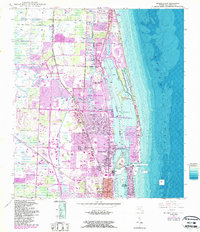
1946 Map of Riviera Beach
USGS Topo · Published 1987About this map
Lake Worth and the Intracoastal Waterway serve as the central nervous system for this coastal corridor, which reflects significant post-war development and nautical infrastructure. Originally surveyed in the 1940s and updated with 1980s data, the map tracks the growth of communities like North Palm Beach and Palm Beach Gardens. The landscape is defined by its complex shoreline, from the barrier island reaches of Singers Island and Palm Beach Shores to the protected waters around Peanut Island and Munyon I. Maritime activity is concentrated near the Lake Worth Inlet, where the U S Coast Guard Station stands watch. Inland, the arrival of the Seaboard and Florida East Coast rail lines influenced the early layout of Lake Park and Riviera Beach, while preserved spaces like the John D MacArthur Beach State Recreation Area provide a contrast to the dense municipal footprints.
Find a feature on this map
32 named features on this map. Tap any name to fly to it.
Don’t see what you’re looking for? This feature index may not catch every label — zoom into the map to look around manually.
Map Details
Editions of this 1946 Riviera Beach Map
4 editions found
Other maps of this area

1945 · Delta
USGS Topo · 1:24,000

1946 · Riviera Beach
USGS Topo · 1:24,000

1946 · Palm Beach Farms
USGS Topo · 1:24,000

1946 · Palm Beach
USGS Topo · 1:24,000

1948 · Rood
USGS Topo · 1:24,000

1948 · Jupiter
USGS Topo · 1:24,000

1949 · Rood
USGS Topo · 1:24,000

1949 · Palm Beach Farms
USGS Topo · 1:24,000

1949 · Riviera Beach
USGS Topo · 1:24,000

1950 · Jupiter
USGS Topo · 1:24,000