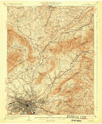
1933 Map of Roanoke
USGS Topo · Published 1933About this map
Roanoke serves as the industrial and transport heart of this valley, where the Norfolk and Western and Virginian railroads intersect along the Roanoke River. The 1933 landscape reveals a dense network of rural infrastructure, from the historic seat of Fincastle in the north to the expanding campus of Hollins College. This survey captures the region before major mid-century suburbanization, showing a tapestry of family-scale education and faith at sites like Fancy View Sch, Howells Chapel Sch, and Jones Chapel. The terrain is strictly defined by the ridges of Tinker Mountain and the Blue Ridge, which forced early travel corridors like the Lee Highway to navigate specific gaps and hollows. Local water power and early industry are evident at Glebe Mills and Howell Mills, marking the transition from a purely agrarian economy to a regional commercial hub.
Find a feature on this map
86 named features on this map. Tap any name to fly to it.
Don’t see what you’re looking for? This feature index may not catch every label — zoom into the map to look around manually.
Map Details
Editions of this 1933 Roanoke Map
3 editions found

Other maps of this area

1887 · Lewisburg
USGS Topo · 1:125,000

1890 · Roanoke
USGS Topo · 1:125,000

1890 · Christiansburg
USGS Topo · 1:125,000

1891 · Roanoke
USGS Topo · 1:125,000

1891 · Lewisburg
USGS Topo · 1:125,000

1894 · Natural Bridge
USGS Topo · 1:125,000

1894 · Natural Bridge
USGS Topo · 1:62,500

1907 · Natural Bridge Special
USGS Topo · 1:62,500

1913 · Eagle Rock
USGS Topo · 1:48,000

1915 · Eagle Rock
USGS Topo · 1:62,500