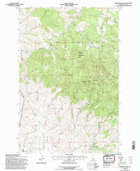
1994 Map of Robinson Lake
USGS Topo · Published 1997About this map
The University of Idaho Experimental Forest dominates the high-elevation center of this topographic study, encompassing the prominent peaks of the Palouse Range. Steep ridges and narrow drainages define the landscape, with summits like West Twin, East Twin, and Paradise Point marking the divide between the north and south watersheds. The northern slopes feed into Fourmile Creek and West Fork Flannigan Creek, while the southern reaches contribute to the South Fork Palouse River system. Historical land use is evidenced by the White Cross Mine located on the southern flank of the range and the Rocky Point Lookout positioned to the northeast. Near the southern boundary, the terrain transitions toward the Paradise Valley, where Robinson Lake and various gaging stations indicate the importance of water management in this high-altitude forestry environment.
Find a feature on this map
22 named features on this map. Tap any name to fly to it.
Don’t see what you’re looking for? This feature index may not catch every label — zoom into the map to look around manually.
Map Details
Editions of this 1994 Robinson Lake Map
2 editions found
Other maps of this area

1910 · Pullman
USGS Topo · 1:125,000

1955 · Pullman
USGS Topo · 1:250,000

1958 · Pullman
USGS Topo · 1:250,000

1960 · Troy
USGS Topo · 1:24,000

1960 · Robinson Lake
USGS Topo · 1:24,000

1960 · Moscow Mtn
USGS Topo · 1:24,000

1960 · Moscow East
USGS Topo · 1:24,000

1960 · Potlatch
USGS Topo · 1:62,500

1961 · Moscow
USGS Topo · 1:62,500

1964 · Viola
USGS Topo · 1:24,000