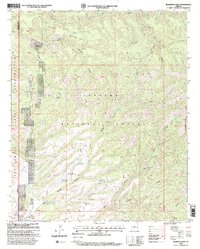
1997 Map of Robinson Mesa
USGS Topo · Published 2000About this map
Honeymoon Ranch and Four Drag Ranch occupy a landscape defined by ranching operations within the Apache National Forest. This high-country territory is characterized by a complex network of stock management infrastructure, including the Robinson Mesa Corral, Mud Springs Corral, and several specialized enclosures like the Holding Pasture Corral and Cutting Pens. The western edge of the map is defined by the boundary of the San Carlos Indian Reservation, while the historic Coronado Trail runs along the eastern ridges. Water management is central to life here, evidenced by a vast system of named tanks and springs, such as Glover Tank and Tercer Springs, which sustain livestock across Robinson Mesa. A pipeline connects several water sources, highlighting the engineering required to support the 7 Cross A Ranch and other outfits in this arid terrain.
Find a feature on this map
56 named features on this map. Tap any name to fly to it.
Don’t see what you’re looking for? This feature index may not catch every label — zoom into the map to look around manually.
Map Details
Editions of this 1997 Robinson Mesa Map
This is the sole edition of this map. No revisions or reprints were ever made.
Other maps of this area

1913 · Morenci
USGS Topo · 1:125,000

1915 · Morenci
USGS Topo · 1:125,000

1922 · Nutrioso
USGS Topo · 1:125,000

1954 · Clifton
USGS Topo · 1:250,000

1957 · Clifton
USGS Topo · 1:250,000

1958 · Clifton
USGS Topo · 1:250,000

1958 · Hannagan Meadow
USGS Topo · 1:62,500

1962 · Clifton
USGS Topo · 1:250,000

1967 · Freezeout Mountain
USGS Topo · 1:24,000

1967 · Robinson Mesa
USGS Topo · 1:24,000