
1967 Map of Roche A Cri
USGS Topo · Published 1969About this map
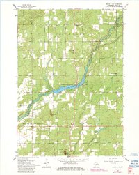
Big Roche a Cri Creek snakes through the central Adams County landscape, defining the character of the Big Roche a Cri Lake reservoir. The area is marked by distinctive geological outcrops such as Rabbit Rock, Minnie Rock, and the namesake Roche a Cri pillar within Roche a Cri State Park. These sandstone mesas rise sharply above the flat plains of Strongs Prairie and Big Flats, providing landmarks that have served travelers for generations. Local life in the late 1960s is anchored by the Pineland Sch, the Cottonville Cem, and a dedicated Wayside Park. The presence of a Cranberry Bog near Bingham Creek reflects the region's specialized agricultural history, while the straight-line grid of roads like Cottonville Avenue and Chicago Avenue contrasts with the meandering paths of Carter Creek and Dead Horse Creek.
Find a feature on this map
25 named features on this map. Tap any name to fly to it.
Don’t see what you’re looking for? This feature index may not catch every label — zoom into the map to look around manually.
Map Details
Editions of this 1967 Roche A Cri Map
2 editions found
Other maps of this area

1955 · Green Bay
USGS Topo · 1:250,000

1957 · Madison
USGS Topo · 1:250,000

1958 · Arkdale
USGS Topo · 1:48,000

1958 · Coloma
USGS Topo · 1:48,000

1960 · Madison
USGS Topo · 1:250,000

1961 · Oxford
USGS Topo · 1:62,500

1961 · Adams
USGS Topo · 1:62,500

1967 · Arkdale NE
USGS Topo · 1:24,000
1967 · Arkdale
USGS Topo · 1:24,000

1968 · Coloma NW
USGS Topo · 1:24,000