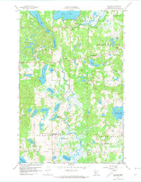
1959 Map of Rochert
USGS Topo · Published 1974About this map
The Otter Tail River winds through a complex glacial landscape in this mid-century portrait of Becker County, feeding into the Hubbel Pond Game Refuge. The settlement of Rochert serves as a local hub, situated between the large Cotton Lake and the meandering river. The map reveals a high density of small water bodies, including Hungry Lake, Alvin Lake, and Pickerel Lake, which are characteristic of the Height of Land region.
Find a feature on this map
40 named features on this map. Tap any name to fly to it.
Don’t see what you’re looking for? This feature index may not catch every label — zoom into the map to look around manually.
Map Details
Editions of this 1959 Rochert Map
3 editions found
Other maps of this area

1912 · Vergas
USGS Topo · 1:62,500

1915 · Perham
USGS Topo · 1:62,500

1915 · Vergas
USGS Topo · 1:62,500

1953 · Brainerd
USGS Topo · 1:250,000

1957 · Brainerd
USGS Topo · 1:250,000

1958 · Brainerd
USGS Topo · 1:250,000

1959 · Toad Mountain
USGS Topo · 1:24,000

1959 · Flat Lake
USGS Topo · 1:24,000

1959 · Rochert
USGS Topo · 1:24,000

1959 · Richwood
USGS Topo · 1:24,000