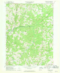
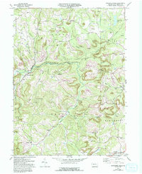
1968 Map of Rochester Mills
USGS Topo · Published 1970About this map
Little Mahoning Creek and Mahoning Creek carve through this section of Indiana County, where the late 1960s landscape is defined by a dense network of extraction and rural community hubs. The map reveals an intensive pattern of resource use, with Strip Mines and numerous Gas Wells dotting the ridges between local heights like Canoe Ridge and Doty Roundtop. Settlement is dispersed among several named hamlets including Rochester Mills, Savan, and Gipsy. For those studying local lineage, the sheet is an excellent record of spiritual and educational life, capturing the locations of the Canoe-Grant Sch, Montgomery Ch, and various burial grounds such as Frye Cem and Rowley Cem. The topography is particularly detailed around Deckers Point and Hillsdale, showing the complex drainage of runs like Salsgiver Run and Broadhead Run.
Find a feature on this map
46 named features on this map. Tap any name to fly to it.
Don’t see what you’re looking for? This feature index may not catch every label — zoom into the map to look around manually.
Map Details
Editions of this 1968 Rochester Mills Map
5 editions found
Other maps of this area

1902 · Indiana
USGS Topo · 1:62,500

1902 · Barnesboro
USGS Topo · 1:62,500

1904 · Barnesboro
USGS Topo · 1:62,500

1906 · Punxsutawney
USGS Topo · 1:62,500

1909 · Smicksburg
USGS Topo · 1:62,500

1938 · Smicksburg
USGS Topo · 1:62,500

1939 · Smicksburg
USGS Topo · 1:62,500

1939 · Punxsutawney
USGS Topo · 1:62,500

1942 · Punxsutawney
USGS Topo · 1:62,500

1943 · Punxsutawney
USGS Topo · 1:125,000
Featured Places
- Banks Township, PA
- North Mahoning Township, PA
- Nashville, Grant Township
- Gorman Summit, Montgomery Township
- Wilgus, Montgomery Township