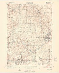
1952 Map of Rochester
USGS Topo · Published 1954About this map
The Clinton River flows through the heart of this Oakland County landscape, marking a period of postwar transition where traditional rural school districts began to yield to suburban growth. Evidence of this shift is found in the high number of defunct local schoolhouses, such as Brewster Sch and Christian Hill Sch, while newer facilities like Avondale High Sch emerge to the south. The village of Rochester serves as a primary hub, bounded by the Stony Creek and the steel of the New York Central railroad tracks.
Find a feature on this map
51 named features on this map. Tap any name to fly to it.
Don’t see what you’re looking for? This feature index may not catch every label — zoom into the map to look around manually.
Map Details
Editions of this 1952 Rochester Map
3 editions found
Other maps of this area

1907 · Pontiac
USGS Topo · 1:62,500

1908 · Rochester
USGS Topo · 1:62,500

1936 · Warren
USGS Topo · 1:31,680

1936 · Birmingham
USGS Topo · 1:31,680

1936 · Rochester
USGS Topo · 1:31,680

1936 · Washington
USGS Topo · 1:31,680

1936 · Pontiac South
USGS Topo · 1:31,680

1936 · Pontiac North
USGS Topo · 1:31,680

1943 · Pontiac South
USGS Topo · 1:24,000

1943 · Pontiac North
USGS Topo · 1:24,000
Featured Places
- Rochester Hills, MI
- Pontiac, MI
- Orion Charter Township, MI
- Auburn Hills, MI
- Oakland Charter Township, MI