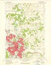
1972 Map of Rochester
USGS Topo · Published 1975About this map
The South Fork Zumbro River snakes through this 1970s landscape, anchoring the city of Rochester as it expands into the surrounding townships of Cascade and Haverhill. The map provides an exceptionally detailed view of the city's institutional heart, including the world-renowned Mayo Clinic and St Marys Hospital. The urban grid is interspersed with numerous civic spaces like Silver Lake Park and Soldiers Field Park, while educational growth is evidenced by a dense network of neighborhood schools from Churchill Sch to the Rochester State Junior College.
Find a feature on this map
73 named features on this map. Tap any name to fly to it.
Don’t see what you’re looking for? This feature index may not catch every label — zoom into the map to look around manually.
Map Details
Editions of this 1972 Rochester Map
4 editions found
Other maps of this area

1935 · Rochester
USGS Topo · 1:48,000

1939 · Rochester
USGS Topo · 1:62,500

1953 · Saint Paul
USGS Topo · 1:250,000

1954 · Mason City
USGS Topo · 1:250,000

1955 · Stewartville
USGS Topo · 1:62,500

1955 · High Forest
USGS Topo · 1:62,500

1957 · Mason City
USGS Topo · 1:250,000

1958 · Mason City
USGS Topo · 1:250,000

1959 · Saint Paul
USGS Topo · 1:250,000

1965 · Oronoco
USGS Topo · 1:24,000