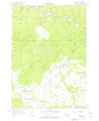
1956 Map of Rochford
USGS Topo · Published 1976About this map
The gold-mining legacy of the Black Hills is clearly visible in this mid-century survey of the central highlands. The settlement of Rochford serves as a focal point, situated near the Standby Mine and a Ranger Station, illustrating the region's dual history of resource extraction and federal land management within the Black Hills National Forest. To the south, the industrial footprint continues with Lookout Mill and the Cuttys Ark Mine, while the Chicago Burlington and Quincy rail line winds through the gulches to reach Mystic.
Find a feature on this map
52 named features on this map. Tap any name to fly to it.
Don’t see what you’re looking for? This feature index may not catch every label — zoom into the map to look around manually.
Map Details
Editions of this 1956 Rochford Map
4 editions found
Other maps of this area

1894 · Deadwood
USGS Topo · 1:125,000

1896 · Harney Peak
USGS Topo · 1:125,000

1901 · Harney Peak
USGS Topo · 1:125,000

1901 · Deadwood
USGS Topo · 1:125,000

1916 · Deadwood
USGS Topo · 1:125,000

1953 · Nemo
USGS Topo · 1:24,000

1953 · Rapid City
USGS Topo · 1:250,000

1954 · Silver City
USGS Topo · 1:24,000

1954 · Hill City
USGS Topo · 1:24,000

1955 · Hot Springs
USGS Topo · 1:250,000