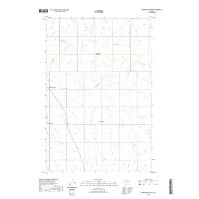
2020 Map of Rock Springs School
USGS Topo · Published 2020About this map
Rock Springs School stands as a central landmark in this high plains landscape, situated near the intersection of several rural routes including E Rock Springs Rd and Angela Rd N. The terrain is defined by a dendritic network of drainages such as Dirty Woman Cr, Rock Springs Cr, and Fulton Cr which carve through the open range. The map illustrates a ranching and agricultural economy dependent on water management, evidenced by the presence of the Kreger Reservoir and Bones Reservoir. Spanning the boundary between Garfield and Rosebud Counties, the settlement of Rock Springs provides a focal point for a remote area characterized by vast public land surveys and section-line roads like Rosebud Road 208 and Uall Rd.
Find a feature on this map
19 named features on this map. Tap any name to fly to it.
Don’t see what you’re looking for? This feature index may not catch every label — zoom into the map to look around manually.
Map Details
Editions of this 2020 Rock Springs School Map
This is the sole edition of this map. No revisions or reprints were ever made.
Other maps of this area

1954 · Forsyth
USGS Topo · 1:250,000

1957 · Forsyth
USGS Topo · 1:250,000

1958 · Forsyth
USGS Topo · 1:250,000

1965 · Rock Springs School
USGS Topo · 1:24,000

1965 · Little Chalk Butte
USGS Topo · 1:24,000
1965 · Crow Rock
USGS Topo · 1:24,000
1965 · Coleman Coulee
USGS Topo · 1:24,000
1965 · Red Buttes
USGS Topo · 1:24,000
1965 · Crow Rock SE
USGS Topo · 1:24,000
1969 · Angela NE
USGS Topo · 1:24,000