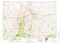
1958 Map of Rock Springs
USGS Topo · Published 1958About this map
Rock Springs and Green River anchor this mid-century look at the high desert of southwestern Wyoming. The corridor established by the Union Pacific railroad and major highways links industrial hubs and coal towns, with a notable concentration of mining and support settlements like Reliance, Stansbury, Winton, and Superior north and east of the main population centers. The presence of a Chemical Plant west of Green River and scattered gas wells across South Baxter Basin underscores the region's long-standing reliance on energy and mineral extraction.
Find a feature on this map
143 named features on this map. Tap any name to fly to it.
Don’t see what you’re looking for? This feature index may not catch every label — zoom into the map to look around manually.
Map Details
Editions of this 1958 Rock Springs Map
2 editions found

Other maps of this area

1885 · Ashley
USGS Topo · 1:250,000

1885 · Uinta
USGS Topo · 1:250,000

1905 · Gilbert Peak
USGS Topo · 1:125,000

1906 · Gilbert Peak
USGS Topo · 1:125,000

1906 · Marsh Peak
USGS Topo · 1:125,000

1908 · Marsh Peak
USGS Topo · 1:125,000

1908 · Rock Springs
USGS Topo · 1:62,500

1910 · Rock Springs
USGS Topo · 1:62,500

1916 · Craig
USGS Topo · 1:125,000

1952 · Willow Creek Butte
USGS Topo · 1:24,000