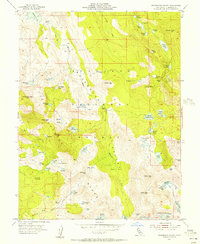
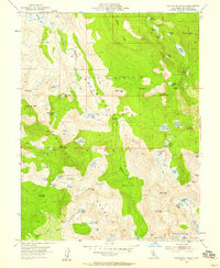
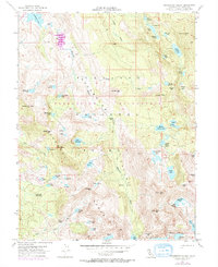
1955 Map of Rockbound Valley
USGS Topo · Published 1956About this map
Eldorado National Forest encompasses this high-altitude landscape of the Sierra Nevada, dominated by the glacier-carved granite of the Rockbound Valley. The 1955 topography shows an extensive network of alpine lakes, from the large expanse of Lake Aloha in the south to Rockbound Lake and Lake Genevieve further north. High peaks including Dicks Peak, Jacks Peak, and McConnell Peak form a jagged perimeter around these glacial basins.
Find a feature on this map
74 named features on this map. Tap any name to fly to it.
Don’t see what you’re looking for? This feature index may not catch every label — zoom into the map to look around manually.
Map Details
Editions of this 1955 Rockbound Valley Map
4 editions found

Other maps of this area

1889 · Pyramid Peak
USGS Topo · 1:125,000

1891 · Truckee
USGS Topo · 1:125,000

1891 · Pyramid Peak
USGS Topo · 1:125,000

1893 · Truckee
USGS Topo · 1:125,000

1895 · Pyramid Peak
USGS Topo · 1:125,000

1895 · Truckee
USGS Topo · 1:125,000

1896 · Pyramid Peak
USGS Topo · 1:125,000

1932 · Truckee
USGS Topo · 1:96,000

1940 · Truckee
USGS Topo · 1:125,000

1947 · Sacramento
USGS Topo · 1:250,000