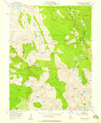
1955 Map of Rockbound Valley
USGS Topo · Published 1959About this map
Eldorado National Forest defines this high-altitude landscape where the Rubicon River carves through the granitic heart of the Sierra Nevada. The 1955 survey documents a wilderness primarily characterized by a dense network of glacial lakes and technical alpine passes. Human activity is concentrated around the Univ Calif Cow Camp and several designated flats like Camper Flat and Willow Flat. Notable water bodies such as Rockbound Lake, Lake Aloha, and the remote Lake Schmidell provide a detailed view of the region's hydrography before modern recreational intensity changed the backcountry. The inclusion of the Red Peak Trail and various unnamed paths illustrates the historical access routes used by early forest rangers and hikers moving between summits like Mcconnell Peak and Dicks Peak.
Find a feature on this map
71 named features on this map. Tap any name to fly to it.
Don’t see what you’re looking for? This feature index may not catch every label — zoom into the map to look around manually.
Map Details
Editions of this 1955 Rockbound Valley Map
4 editions found
Other maps of this area

1889 · Pyramid Peak
USGS Topo · 1:125,000

1891 · Truckee
USGS Topo · 1:125,000

1891 · Pyramid Peak
USGS Topo · 1:125,000

1893 · Truckee
USGS Topo · 1:125,000

1895 · Pyramid Peak
USGS Topo · 1:125,000

1895 · Truckee
USGS Topo · 1:125,000

1896 · Pyramid Peak
USGS Topo · 1:125,000

1932 · Truckee
USGS Topo · 1:96,000

1940 · Truckee
USGS Topo · 1:125,000

1947 · Sacramento
USGS Topo · 1:250,000