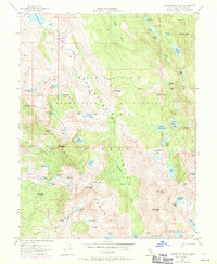
1955 Map of Rockbound Valley
USGS Topo · Published 1971About this map
Desolation Valley Wilderness Area defines the high-altitude landscape of El Dorado County shown here during a mid-century period of hydrologic study and recreational mapping. The headwaters of the Rubicon River dominate the drainage pattern, flowing through the central Rockbound Valley where the Rubicon Reservoir and Rockbound Lake manage the Sierra Nevada snowmelt. The presence of the Univ Calif Cow Camp and various established campsites like Camper Flat highlight the era's mix of traditional land use and growing wilderness tourism. The terrain is marked by dozens of alpine water bodies, including Lake Aloha, Lake Lois, and the 4-Q Lakes, all linked by a network of high-country routes such as the Red Peak Trail. Peaks like Silver Peak and Phipps Peak frame the valley, providing clear reference points for the 1969 photorevisions shown in purple.
Find a feature on this map
70 named features on this map. Tap any name to fly to it.
Don’t see what you’re looking for? This feature index may not catch every label — zoom into the map to look around manually.
Map Details
Editions of this 1955 Rockbound Valley Map
4 editions found
Other maps of this area

1889 · Pyramid Peak
USGS Topo · 1:125,000

1891 · Truckee
USGS Topo · 1:125,000

1891 · Pyramid Peak
USGS Topo · 1:125,000

1893 · Truckee
USGS Topo · 1:125,000

1895 · Pyramid Peak
USGS Topo · 1:125,000

1895 · Truckee
USGS Topo · 1:125,000

1896 · Pyramid Peak
USGS Topo · 1:125,000

1932 · Truckee
USGS Topo · 1:96,000

1940 · Truckee
USGS Topo · 1:125,000

1947 · Sacramento
USGS Topo · 1:250,000