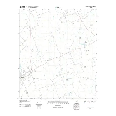
2010 Map of Rockdale East
USGS Topo · Published 2010About this map
The town of Rockdale sits at the western edge of this Milam County landscape, serving as a focal point for a region defined by its rural heritage and scattered landmarks. Numerous burial grounds, including the Old Salem Cemetery, New Salem Cemetery, and the San Jose - Witcher Cemetery, offer significant points of interest for genealogists tracking local family histories. The terrain is marked by gentle elevations such as Hart Mountain and Taylor Mountain, while water features like Mustang Creek and Sandy Creek drain the countryside toward the B and B Minnow Farm Lake. Economic activity is evident through the Houston-Oklahoma Oil Field in the north and the H H Coffield Regional Airport to the south. This survey also records the location of the Cervantes Post Office and several private ranch assets like the Meco Ranch Lake, reflecting the area's agricultural and industrial infrastructure.
Find a feature on this map
64 named features on this map. Tap any name to fly to it.
Don’t see what you’re looking for? This feature index may not catch every label — zoom into the map to look around manually.
Map Details
Editions of this 2010 Rockdale East Map
This is the sole edition of this map. No revisions or reprints were ever made.
Other maps of this area

1885 · Taylor
USGS Topo · 1:125,000

1887 · Taylor
USGS Topo · 1:125,000

1894 · Taylor
USGS Topo · 1:125,000

1954 · Austin
USGS Topo · 1:250,000

1956 · Milano
USGS Topo · 1:62,500

1961 · Hanover
USGS Topo · 1:24,000

1961 · Cameron
USGS Topo · 1:24,000

1961 · Rockdale East
USGS Topo · 1:24,000

1962 · Rockdale West
USGS Topo · 1:24,000
1962 · Pettibone
USGS Topo · 1:24,000