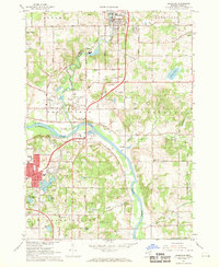
1967 Map of Rockford
USGS Topo · Published 1969About this map
The confluence of the Rogue River and Grand River anchors this late 1960s study of Kent County's changing landscape. While the city of Rockford shows significant development at the northern edge, the surrounding townships of Plainfield, Algoma, and Cannon maintain a mix of rural agriculture and early suburban transition. The presence of numerous Gravel Pits and Sandpits throughout the river valleys points to the era's active construction and road-building needs.
Find a feature on this map
73 named features on this map. Tap any name to fly to it.
Don’t see what you’re looking for? This feature index may not catch every label — zoom into the map to look around manually.
Map Details
Editions of this 1967 Rockford Map
3 editions found
Other maps of this area

1914 · Grand Rapids
USGS Topo · 1:62,500

1918 · Cedar Springs
USGS Topo · 1:62,500

1918 · Lowell
USGS Topo · 1:62,500

1943 · Cedar Springs
USGS Topo · 1:62,500

1943 · Grand Rapids
USGS Topo · 1:62,500

1943 · Lowell
USGS Topo · 1:62,500

1954 · Midland
USGS Topo · 1:250,000

1958 · Midland
USGS Topo · 1:250,000

1958 · Grand Rapids
USGS Topo · 1:250,000

1959 · Midland
USGS Topo · 1:250,000