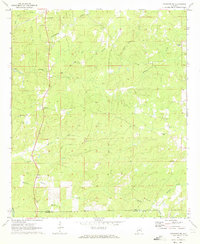
1971 Map of Rockford SW
USGS Topo · Published 1973About this map
Pentonville and the surrounding rural landscapes of Coosa County are defined by a network of small family-named creeks and traditional country churches in the early 1970s. The terrain transitions from the Hachemadega Creek drainage in the north toward the Coosa and Elmore county line in the south, where the settlement of Weoka is established near Bethesda Creek. The prevalence of community anchors such as Pleasant Hill Ch, Rehoboth Ch, and Shady Grove Ch suggests a deeply rooted social structure typical of central Alabama's upland farms.
Find a feature on this map
23 named features on this map. Tap any name to fly to it.
Don’t see what you’re looking for? This feature index may not catch every label — zoom into the map to look around manually.
Map Details
Editions of this 1971 Rockford SW Map
2 editions found
Other maps of this area

1901 · Wetumpka
USGS Topo · 1:125,000

1901 · Wetumpka
USGS Topo · 1:62,500

1903 · Wetumpka
USGS Topo · 1:125,000

1953 · Montgomery
USGS Topo · 1:250,000

1956 · Montgomery
USGS Topo · 1:250,000

1957 · Montgomery
USGS Topo · 1:250,000
1959 · Wetumpka
USGS Topo · 1:62,500

1959 · Elmore
USGS Topo · 1:62,500

1971 · Richville
USGS Topo · 1:24,000
1971 · Flag Mountain
USGS Topo · 1:24,000