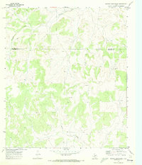
1970 Map of Rocking Chair Ranch
USGS Topo · Published 1973About this map
Kickapoo Creek winds through the northern reaches of this West Texas landscape, where the boundary between Tom Green Co and Schleicher Co is clearly delineated. The terrain is defined by its ranching and resource extraction history, evident in the distribution of isolated homesteads and industrial markings. Large pastoral holdings like Rocking Chair Ranch and Crowbar Ranch occupy significant portions of the acreage, separated by fence lines that reveal the management of this open range in the late 1960s.
Find a feature on this map
8 named features on this map. Tap any name to fly to it.
Don’t see what you’re looking for? This feature index may not catch every label — zoom into the map to look around manually.
Map Details
Editions of this 1970 Rocking Chair Ranch Map
2 editions found
Other maps of this area

1892 · San Angelo
USGS Topo · 1:125,000

1893 · Fort McKavett
USGS Topo · 1:125,000

1954 · Sonora
USGS Topo · 1:250,000

1954 · San Angelo
USGS Topo · 1:250,000

1958 · Sonora
USGS Topo · 1:250,000

1958 · San Angelo
USGS Topo · 1:250,000

1963 · Adams
USGS Topo · 1:24,000

1965 · San Angelo
USGS Topo · 1:250,000

1970 · Rocking Chair Ranch
USGS Topo · 1:24,000
1970 · Burr Oak Creek
USGS Topo · 1:24,000