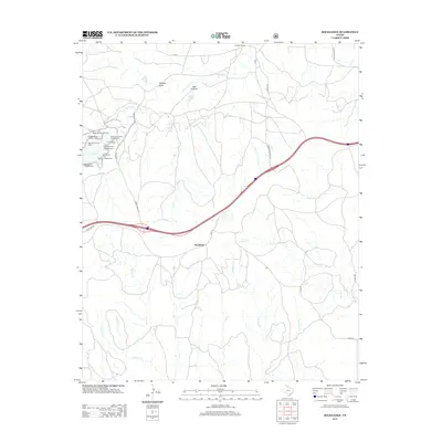
2012 Map of Rockledge
USGS Topo · Published 2012About this map
Lake McClellan serves as the primary recreational and geographic focal point for this section of the Texas Panhandle, surrounded by a high density of public access points including McDowell Campground, Fishermans Point Campground, and the McClellan Picnic Area. The landscape is defined by the drainage network of McClellan Cr, which feeds the lake from the northwest, and a series of ephemeral watercourses like Tibbetts Draw and Jack Canyon. The small settlement of Rockledge sits centrally along a major divided highway that cuts across the ranching country, providing a stark contrast to the winding rural routes like Hessey Rd and Johnson Ranch Rd. Toward the south, the terrain becomes increasingly dissected by numerous creeks, such as Saddlers Cr and Barron Cr, which eventually flow toward the larger Whitefish Cr system.
Find a feature on this map
34 named features on this map. Tap any name to fly to it.
Don’t see what you’re looking for? This feature index may not catch every label — zoom into the map to look around manually.
Map Details
Editions of this 2012 Rockledge Map
This is the sole edition of this map. No revisions or reprints were ever made.
Other maps of this area

1954 · Amarillo
USGS Topo · 1:250,000

1958 · Amarillo
USGS Topo · 1:250,000

1959 · Troublesome Creek
USGS Topo · 1:24,000

1962 · Roach Ranch
USGS Topo · 1:24,000

1962 · Griffin Ranch
USGS Topo · 1:24,000

1962 · Hudgens Ranch
USGS Topo · 1:24,000

1963 · Alanreed
USGS Topo · 1:24,000

1964 · Jericho
USGS Topo · 1:24,000

1964 · Rockledge
USGS Topo · 1:24,000

1968 · Taylor Ranch
USGS Topo · 1:24,000