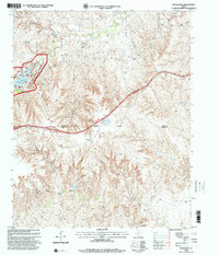
1998 Map of Rockledge
USGS Topo · Published 2001About this map
McClellan Creek National Grassland dominates the northwestern portion of this Texas Panhandle landscape, where the waters of McClellan Creek are impounded to form Lake McClellan. This corner of the map features several recreational and geographic landmarks, including Stilling Pond Trail and McClellan Creek Trail, alongside distinctive terrain features like East Bluff 1 and Southside. A network of drainage systems, including Jack Canyon and Tibbetts Draw, feeds into the creek system, illustrating the erosive patterns typical of the region.
Find a feature on this map
28 named features on this map. Tap any name to fly to it.
Don’t see what you’re looking for? This feature index may not catch every label — zoom into the map to look around manually.
Map Details
Editions of this 1998 Rockledge Map
This is the sole edition of this map. No revisions or reprints were ever made.
Other maps of this area

1954 · Amarillo
USGS Topo · 1:250,000

1958 · Amarillo
USGS Topo · 1:250,000

1959 · Troublesome Creek
USGS Topo · 1:24,000

1962 · Roach Ranch
USGS Topo · 1:24,000

1962 · Griffin Ranch
USGS Topo · 1:24,000

1962 · Hudgens Ranch
USGS Topo · 1:24,000

1963 · Alanreed
USGS Topo · 1:24,000

1964 · Jericho
USGS Topo · 1:24,000

1964 · Rockledge
USGS Topo · 1:24,000

1968 · Taylor Ranch
USGS Topo · 1:24,000