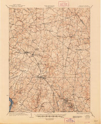
1923 Map of Rockville
USGS Topo · Published 1948About this map
Rockville and the surrounding Maryland countryside are captured here in a transition between rural agrarian roots and the early growth of suburban communities. The regional landscape is defined by the heavy presence of the Baltimore and Ohio Railroad, which threads through key stops like Gaithersburg and the religious retreat grounds of Washington Grove. To the south, transportation is further augmented by the Georgetown and Rockville Electric Railroad, indicating the increasing connectivity toward the national capital. The map details an intricate network of waterways such as Great Seneca Creek and Cabin John Creek, alongside local landmarks like the Montgomery Country Club. Smaller settlements such as Sandy Spring, Brookeville, and Olney anchor the northern reaches of the county, connected by historic thoroughfares like the Frederick Road and Piney Meeting House Road.
Find a feature on this map
91 named features on this map. Tap any name to fly to it.
Don’t see what you’re looking for? This feature index may not catch every label — zoom into the map to look around manually.
Map Details
Editions of this 1923 Rockville Map
4 editions found

Other maps of this area

1890 · Mt. Vernon
USGS Topo · 1:125,000

1891 · Mt. Vernon
USGS Topo · 1:125,000

1892 · Laurel
USGS Topo · 1:62,500

1892 · Ellicott
USGS Topo · 1:62,500

1893 · Frederick
USGS Topo · 1:125,000

1894 · Ellicott
USGS Topo · 1:62,500

1894 · Laurel
USGS Topo · 1:62,500

1894 · Frederick
USGS Topo · 1:125,000

1894 · Mt. Vernon
USGS Topo · 1:125,000

1897 · Laurel
USGS Topo · 1:62,500