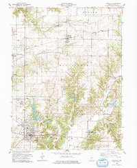
1978 Map of Rockville
USGS Topo · Published 1978About this map
Billie Creek Village and several historic crossing points define this portion of Parke County during the late 1970s. The landscape is characterized by its preservation of structural heritage, notably the Beeson Covered Bridge and Adams Covered Bridge, alongside active civic sites like the 4-H Club Fairgrounds. The town of Rockville serves as the primary hub, where an Armory and a Drive-in Theater are situated near the banks of Rockville Lake.
Find a feature on this map
52 named features on this map. Tap any name to fly to it.
Don’t see what you’re looking for? This feature index may not catch every label — zoom into the map to look around manually.
Map Details
Editions of this 1978 Rockville Map
2 editions found
Other maps of this area

1948 · Wallace
USGS Topo · 1:24,000

1949 · Alamo
USGS Topo · 1:24,000

1951 · Mecca
USGS Topo · 1:24,000

1951 · Mansfield
USGS Topo · 1:24,000

1952 · Catlin
USGS Topo · 1:24,000

1953 · Indianapolis
USGS Topo · 1:250,000

1955 · Rockville
USGS Topo · 1:24,000

1955 · Kingman
USGS Topo · 1:24,000

1955 · Montezuma
USGS Topo · 1:24,000

1956 · Indianapolis
USGS Topo · 1:250,000