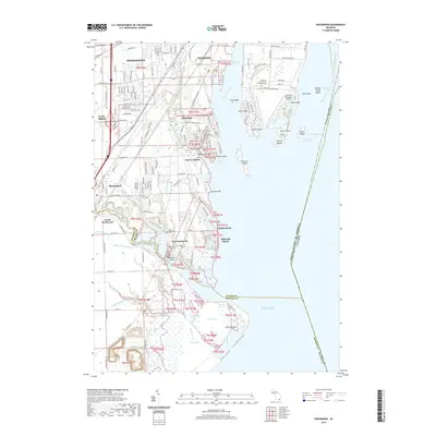
2019 Map of Rockwood
USGS Topo · Published 2019About this map
Rockwood and its neighboring riverfront communities occupy a landscape defined by the convergence of the Huron River and the Detroit River as they enter Lake Erie. The settlement pattern reflects a deeply aquatic geography, where towns like Gibraltar and South Rockwood are stitched together by a complex network of drains and creeks, including the Frank and Poet Drain and Silver Creek. Along the coastline, seasonal or residential enclaves like Maple Beach and Milleville Beach sit near the extensive wetlands of Point Mouillee, while the Trenton Channel separates the mainland from a chain of significant islands such as Celeron Island, Hickory Island, and Elba Island. Local transit and commerce are anchored by the Norfolk Southern rail line and the presence of the Grosse Ile Municipal Airport at the map's eastern edge. The map captures the specialized land use of the Wayne and Monroe County border, balancing industrial corridors with significant conservation areas and small-town residential hubs.
Find a feature on this map
89 named features on this map. Tap any name to fly to it.
Don’t see what you’re looking for? This feature index may not catch every label — zoom into the map to look around manually.
Map Details
Editions of this 2019 Rockwood Map
This is the sole edition of this map. No revisions or reprints were ever made.
Other maps of this area

1906 · Wyandotte
USGS Topo · 1:62,500

1906 · Romulus
USGS Topo · 1:62,500

1912 · Wyandotte
USGS Topo · 1:62,500

1912 · Monroe
USGS Topo · 1:62,500

1914 · Monroe
USGS Topo · 1:62,500

1928 · Romulus
USGS Topo · 1:62,500

1929 · Wyandotte
USGS Topo · 1:62,500

1936 · Wyandotte
USGS Topo · 1:31,680

1936 · Rockwood
USGS Topo · 1:31,680

1936 · Stony Point
USGS Topo · 1:31,680